The Visimind company provides advanced solutions based on the latest technological advancements, enabling comprehensive monitoring, analysis, and optimization of both existing and newly constructed road infrastructure.
We specialize in services such as laser scanning, orthophotomaps, photogrammetry, and 3D modeling. We leverage state-of-the-art technologies to ensure the highest quality and precision in data acquisition for our clients.
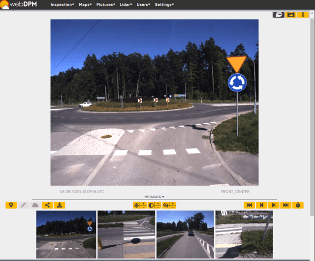
By utilizing our services, you will receive not only comprehensive information about the surveyed area but also visualization through our proprietary software. This will provide you with a complete understanding of the collected data, allowing you to make informed decisions and effectively manage the project.
Visimind offers a wide range of solutions based on the latest technologies to help monitor, analyze, and optimize the operation of existing infrastructure and the development of new road infrastructure. We conduct laser scanning, orthophotomaps, photogrammetry, and 3D modeling. All acquired data is visualized in our proprietary software for your convenience.
Road lane imaging
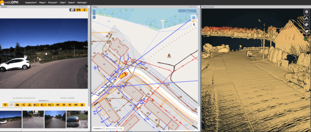
Photographic documentation, enabling continuous monitoring of the actual condition of roads and tracking changes using helicopters, drones, or vehicles, is a key element of modern road infrastructure management. This process involves acquiring, analyzing, and interpreting visual data, which is then used to make decisions regarding road maintenance, modernization, and development.
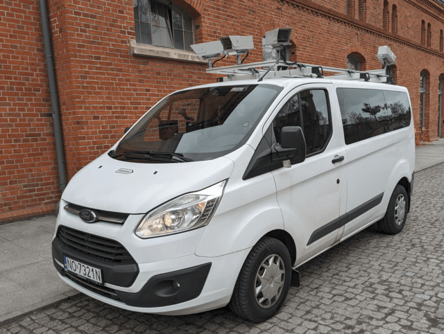
In practice, creating such documentation may involve several key steps. Initially, various platforms are used to collect data, such as helicopters, drones, or vehicles equipped with specialized cameras and sensors. These platforms travel along roads, capturing images and collecting geospatial data.
The next step is processing the collected data, locating it in the appropriate coordinate system, and quality control of the gathered material. This entire process not only provides current information about the state of roads but also enables monitoring of changes, such as damages, topographic alterations, or infrastructure expansions.
By regularly updating photographic documentation, road managers can make informed decisions regarding conservation, repairs, and long-term road network planning.

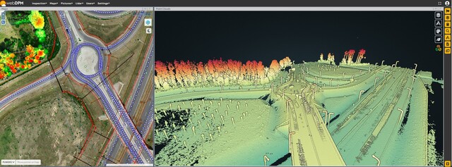
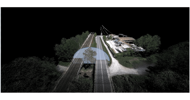
Road lane scanning - point cloud
As part of road lane traversal and photographic documentation, it's possible to gather additional data using a laser scanner. This advanced system enables the generation of a point cloud containing precise information about distances, heights, surfaces, and volumes of the terrain and road infrastructure elements. It allows for accurate measurement of every detail in the area.
Our terrain data acquisition system enables simultaneous photography and laser scanning, allowing for comprehensive documentation of the road and its surroundings. After completing the task, the gathered data is accessible via dedicated software. This provides users with the opportunity to analyze, process, and utilize the collected information quickly and effectively, enabling better management of road infrastructure and informed decision-making regarding conservation, modernization, and road network development.
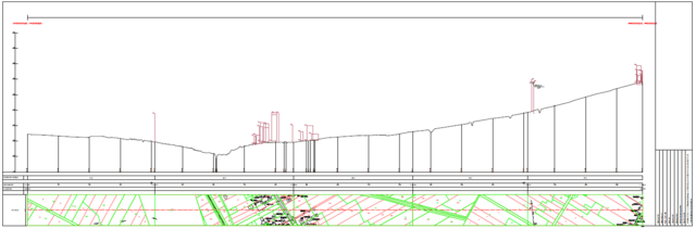
Road Investment Planning
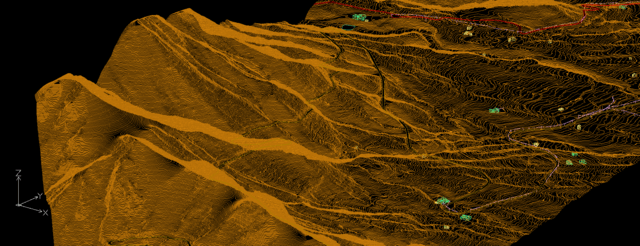
We use laser scanning to conduct comprehensive reflections of the investment area, which serves as an essential foundation for various engineering and construction projects. Our services also include creating orthophoto maps and presenting the planned investment area precisely and in detail.
Additionally, we produce Digital Terrain Models (DTMs), allowing for digital visualization of the terrain relief. This enables accurate depiction of terrain features such as slopes, gradients, and elevations, providing crucial information for designers, engineers, and decision-makers involved in planning infrastructure investments.
Our company utilizes state-of-the-art technologies and surveying methods, ensuring high precision and quality geodetic services. As a result, our clients can be confident in possessing comprehensive and reliable data necessary for effective planning, designing, and implementation of various construction and infrastructure projects.
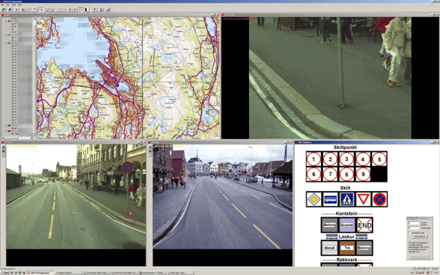
Data Update
Our team is engaged in updating GIS (Geographic Information System) data, providing comprehensive information on traffic safety and urban infrastructure. As part of our services, we focus on collecting, analyzing, and updating data related to various elements of the road environment, such as road signs, bus stops, curbs, and more.
Using advanced Visimind technology, we are capable of conducting a complete inventory and updating the GIS databases you already possess. This advanced technology allows us to effectively map and collect field data, enabling accurate representation of existing infrastructure and any changes that may have occurred over time.
Our services not only ensure the currency and accuracy of GIS data but also enable better management of road infrastructure and more informed decision-making regarding traffic safety and urban planning. Thanks to our specialized services, clients can be confident that they have a complete and up-to-date picture of their environment, which is crucial for the effective functioning and development of urban infrastructure.
Detection of dead and hazardous trees
Detecting sick, dying, and dead trees along the roadside is an important action aimed at ensuring road traffic safety. Our advanced technologies and measurement methods enable the effective identification of potentially dangerous trees that may pose a threat to road users.
As part of our services, we employ various imaging techniques, data analysis, and field inspections to assess the health status of trees near roads accurately. We utilize advanced algorithms and GIS tools to process image and geospatial data, allowing us to detect potential hazards quickly and precisely.
Our efforts not only aim to identify diseased, dying, and dead trees but also to provide a comprehensive data and detailed recommendations for remedial actions. This enables road managers to take adequate preventive measures, such as pruning or removal, to minimize the risk of accidents and ensure safety for all road users. Our actions contribute to improving road infrastructure and reducing potential hazards associated with the presence of dangerous trees near roads.
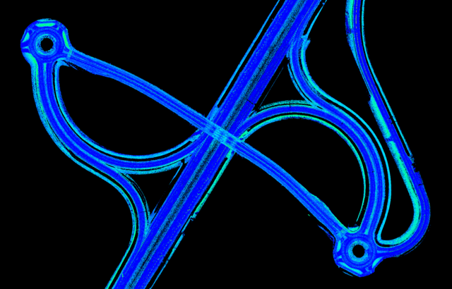
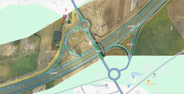
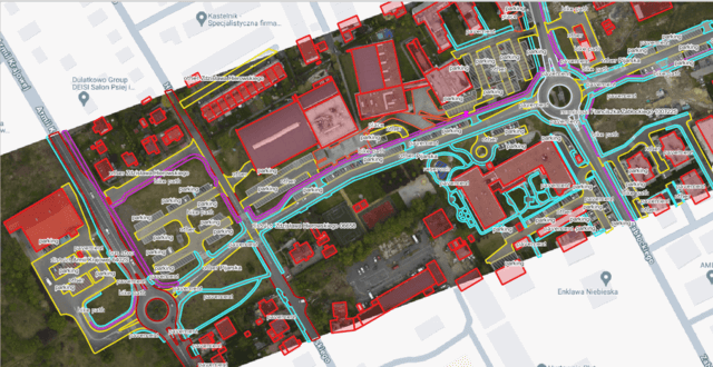
Road Infrastructure Vectorization
Road infrastructure vectorization is a crucial process enabling precise visualization of roads in a two-dimensional space (2D), complemented by essential information regarding these roads. This advanced process involves transforming data from images or raster maps into vector form, allowing for a more accurate, flexible, and easily manageable representation of road infrastructure in GIS software.
During vectorization, each element of road infrastructure, such as roads, intersections, sidewalks, or road signs, is represented as a vector object containing a series of informational attributes. These attributes may include road names, road class, pavement type, or information about objects surrounding the roads that may affect their condition or use.
Through meticulous vectorization, it becomes possible to accurately depict road infrastructure and incorporate significant information that can be leveraged for road condition verification and removal of unwanted objects from the road space. This data accessibility enables quicker and more effective actions in road maintenance, identification of potential risk points, or planning road infrastructure upgrades, empowering road maintenance and planning authorities with enhanced decision-making tools.
By virtue of road infrastructure vectorization, we are able to enhance road infrastructure management, thereby significantly bolstering safety for all road users. In addition, it enables more efficient use of resources and better planning of road network maintenance and expansion activities.
Support for ITS Systems
Modern LiDAR (Light Detection and Ranging) sensors are advanced tools enabling precise tracking of object movement at intersections and performing comprehensive path analyses, contributing to the optimization of road networks.
Using LiDAR technology, data on vehicle and pedestrian movement at road intersections can be obtained. This advanced system utilizes laser pulses to rapidly scan the surroundings, allowing for precise determination of the position, speed, and direction of movement of each object at the intersection.
LiDAR data analysis enables a detailed understanding of traffic dynamics at intersections, identification of areas with high traffic volumes, and potential critical points. This information is crucial for road designers and transportation planners as it allows for the optimization of road layouts, implementation of effective traffic management solutions, and improvement of safety at intersections.
By tracking object movement at intersections and performing path analyses using LiDAR sensors, decisions regarding planning, designing, and managing road networks can be made. This tool enables the adaptation of road infrastructure to changing traffic conditions and ensures smoothness and safety in road transportation.
Summary
Our data can be used for various purposes, providing support to clients in multiple areas.
Our goal is to deliver valuable solutions that contribute to improving efficiency, reducing inventory time, addressing potential issues, and optimizing work using modern technologies. With our data and services, our clients can achieve better results in managing road infrastructure and in achieving their business objectives.