We provide comprehensive solutions based on the latest technologies that effectively support inventory, monitoring, and management processes for railway infrastructure. Our innovative approach allows for the utilization of advanced tools and systems that ensure full control over railway infrastructure, bringing numerous benefits to operators and network managers.
Visimind supports the operations of railway enterprises in the following areas:
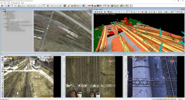
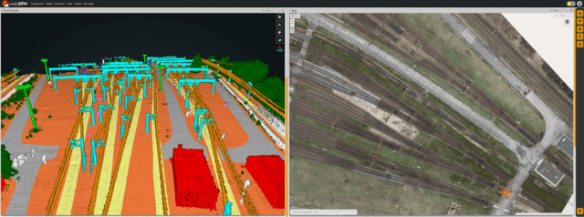
DPM 3D Inspection Software
The application implemented by us, DPM 3D Inspection, constitutes a comprehensive server-based solution supporting railway asset management. This advanced platform integrates capabilities for displaying, visualizing, analyzing, and simulating data from various sensors, including point clouds, maps, photos, and other GIS data. Through our tools, we transform traditional analog asset management into a digital form, bringing numerous benefits to railway operators and infrastructure managers.
The main features and capabilities of our application include:
- 3D data visualization: DPM 3D Inspection enables the visualization of railway infrastructure in three dimensions, enhancing understanding of terrain topography and the location of individual elements.
- Data analysis: This platform allows for advanced analysis of data from different sensors, enabling the identification of anomalies, failures, or potential threats.
- Integration with various types of data: The application integrates data from multiple sources, such as point clouds, orthophotos, images, or vector data, enabling comprehensive analysis and presentation of information.
- Transition to digital form: Our tools support the migration process from traditional analog asset management to modern digital form, contributing to increased efficiency, precision, and safety in the operation of railway infrastructure.
DPM 3D Inspection is an innovative solution that enables better railway asset management, minimizing the risk of failures and optimizing maintenance and modernization processes.
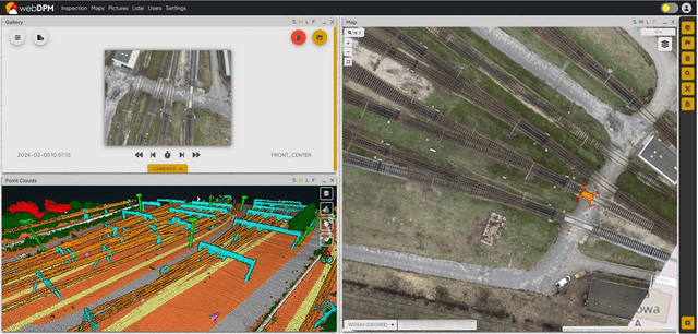
Mapping and 3D modeling of railway infrastructure
Performing area mapping and converting traditional documentation into digital form, including database-based asset passportization, are key steps in building a Digital Twin for managing of infrastructure. A Digital Twin is a virtual model that reflects the real infrastructure, enabling comprehensive monitoring, analysis, and management.
Here's how these actions support the construction of a Digital Twin:
- Terrain mapping: The process of area mapping involves collecting geospatial data using various technologies such as laser scanners, orthogonal cameras, inspection cameras, or thermal sensors. These data are then used to create a three-dimensional terrain model, which serves as the basis for the Digital Twin. Through this mapping, we can obtain precise information about the topography, location of infrastructure elements, and other significant terrain features.
- Conversion of documentation into digital form: Existing documents, technical drawings, and other infrastructure-related materials are digitized and transferred into digital form. These data are then integrated with terrain mapping data, allowing for a comprehensive representation of the infrastructure in a digital environment.
- Database-based asset passportization: Transforming traditional documentation into a database form enables structured storage and management of information regarding individual infrastructure elements. Each element can be described using a range of parameters, facilitating identification, analysis, and planning of maintenance and modernization activities.
- Constructing a digital infrastructure model based on such data enables railway operators and infrastructure managers to better understand the state and behavior of the infrastructure in real-time. This allows for quick response to failures and changes, optimization of maintenance activities, and forecasting future needs and threats.
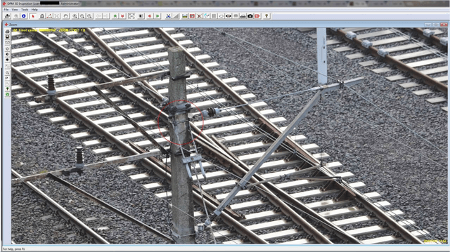
Visual inspections of infrastructure
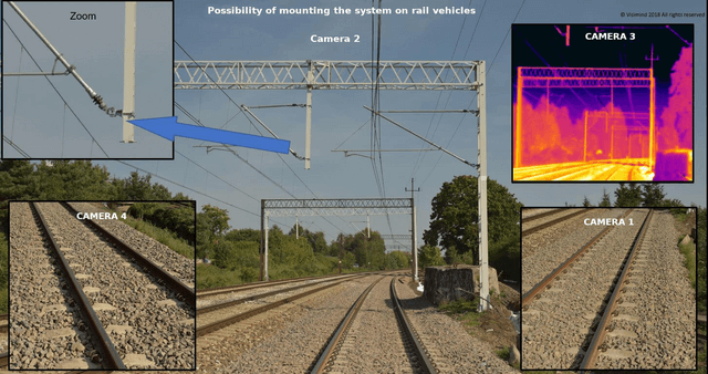
Identification of defects and monitoring of infrastructure using a mobile, aerial, and unmanned data acquisition system is an effective strategy for preventing failures and maintaining a high standard of safety and functionality in railway infrastructure.
Here's how such a system can operate:
- Mobile data acquisition system: A mobile system can be used by field personnel moving around the railway infrastructure. At its simplest, this could be a handheld device or even a smartphone equipped with appropriate applications and tools. Using the mobile system, employees can quickly and easily record data regarding the condition of the infrastructure, such as damages, wear and tear, or other abnormalities. The system can be integrated with a database and management system, enabling immediate analysis of the gathered information and appropriate corrective actions.
- Aerial data acquisition system: An aerial system, such as a drone or helicopter, can be used to swiftly scan the area of railway infrastructure from the air. These can be equipped with advanced sensors, such as high-resolution cameras or laser scanners, which enable precise imaging of the terrain and identification of potential defects or hazards. Aerial scanning can be conducted regularly, allowing for monitoring changes over time and quick response to emerging issues.
- Rail-mounted data acquisition system: Advanced sensors used in the inspection and mapping of railway areas can be mounted on rail vehicles. This type of installation allows for regular updates during routine railway operations.
- Controlling and documenting infrastructure using various data acquisition systems allows for the rapid identification of defects and effective response to emerging problems, contributing to the improvement of safety and reliability in railway infrastructure.
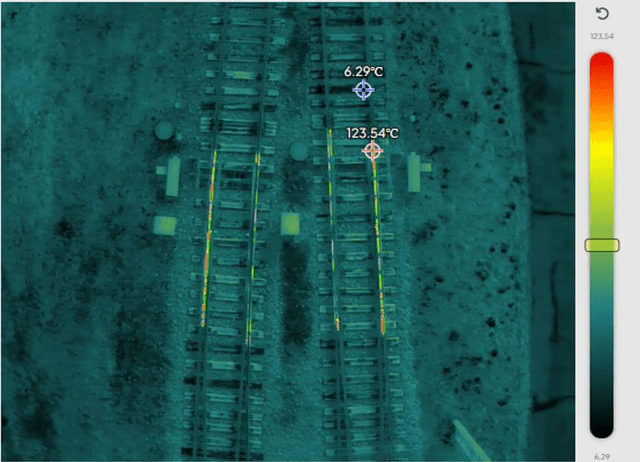
Thermal inspections
Conducting inspections of clients' infrastructure using the latest thermal imaging sensors is an effective method for monitoring the technical condition and safety of railway infrastructure. The use of thermal imaging sensors allows for the detection of temperature changes, which can indicate potential problems such as overheating elements, heat leaks, or the presence of fire.
Here are several benefits of this approach:
- Detection of issues invisible in standard RGB cameras : A thermal imaging sensor can detect even the smallest temperature differences, enabling the identification of faults or abnormalities that may be invisible during classical visual inspections.
- Quick fault localization: With a thermal imaging sensor, it's possible to quickly pinpoint areas where temperature anomalies occur, speeding up the process of identifying and repairing faults.
- Preventive maintenance actions: Regular thermal imaging inspections allow for the early detection of potential problems, enabling preventive actions to prevent major failures or damage.
- Optimization of infrastructure maintenance: Monitoring railway infrastructure using thermal imaging sensors allows for the optimization of maintenance processes by focusing on areas that require the most attention and repair.
Utilizing the latest thermal imaging sensors during infrastructure inspections ensures effective safety and maintenance management, leading to increased reliability and efficiency of railway infrastructure.
Railway investment planning
Utilizing point cloud data from laser scanning and orthophotomaps allows for obtaining detailed information about railway infrastructure, enabling precise analysis and terrain modeling without the need for fieldwork and additional measurements.
Here are several benefits of this approach:
- Detailed analysis: Point cloud data from laser scanning provides rich information about the terrain's topography, object locations, as well as their heights and shapes. This allows for a detailed analysis of each element of railway infrastructure.
- Terrain modeling: Based on point cloud data and orthophotomaps, a three-dimensional terrain model can be created, accurately reflecting reality. Such a model serves as an excellent basis for planning the development, reconstruction, or modernization of railway infrastructure networks.
- Development concept creation: With the created railway infrastructure model, various development concepts can be easily devised, analyzing their impact on existing infrastructure and the surrounding terrain. Simulations can be conducted to assess the effects of different scenarios without the need for costly fieldwork.
- Modernization and reconstruction planning: With an accurate model of railway infrastructure, actions related to modernization, reconstruction, or expansion of the railway network can be precisely planned. It becomes easy to identify areas requiring attention and predict potential problems and challenges.
- Resource optimization: With precise data from point clouds and orthophotomaps, resources can be managed more efficiently, minimizing costs and the risk of erroneous decisions.
Creating a model of railway infrastructure based on point cloud data from laser scanning and orthophotomaps is an incredibly useful tool that enables comprehensive analysis, planning, and modeling without the need for additional field measurements.
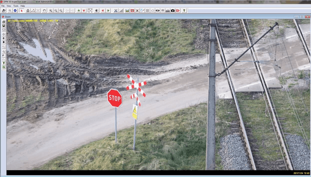
Intersection safety inspection
Utilizing aerial data acquisition system images for inspecting and securing intersections with railway infrastructure can be an effective and efficient tool.
Here are several benefits of this approach:
- Bird's-eye view perspective: These images provide a bird's-eye view perspective, allowing for a detailed aerial inspection of the entire intersection. This makes it easier to identify potential problems and damages that may be difficult to notice from ground level.
- Speed and efficiency: We can quickly map the intersection area by capturing images from various angles and perspectives. This enables a rapid overview of the entire intersection and swift identification of any issues.
- Image accuracy: Modern high-resolution cameras provide very accurate images, allowing even the smallest damages or abnormalities on railway infrastructure or surrounding areas to be noticed.
- Minimal disruption to traffic: Utilizing aerial systems for intersection inspection minimizes disruptions to road and rail traffic. There is no need to close roads or railway lines for extended periods, ensuring smooth traffic flow.
- Documentation capability: The images can be used for precise documentation of the intersection's condition and any repairs or upgrades. They enable easy comparison of the railway infrastructure's condition at different times and monitoring of work progress.
Utilizing aerial data acquisition system images for intersection inspection and securing with railway infrastructure can bring many benefits, such as speed, accuracy, minimal disruption to traffic, and the ability to document precisely. It's an efficient tool that can be effectively used in railway infrastructure maintenance and management processes.
Continuous monitoring of railway areas
Securing the railway inSecuring railway infrastructure areas using modern space surveillance systems based on LiDAR sensors can provide effective protection against threats and enable rapid response to potential incidents.
Here are several benefits of utilizing these advanced systems:
- Intruder detection: LiDAR sensors can effectively detect motion and the presence of intruders in railway infrastructure areas. With high accuracy and speed of measurements, these systems can immediately react to unauthorized access and trigger alarms.
- Area monitoring: Surveillance systems based on LiDAR sensors enable continuous monitoring of railway infrastructure areas in real-time. This allows security personnel to swiftly respond to any irregularities.
- High measurement accuracy: LiDAR technology ensures high accuracy of three-dimensional measurements, enabling precise determination of the position and movement of objects in space. This facilitates effective detection of even small or rapidly moving objects.
- Operation in various weather conditions: LiDAR systems are capable of functioning in different weather conditions, including poor visibility or nighttime. This ensures that surveillance of railway infrastructure can be maintained regardless of weather conditions.
- Integration with alarm systems: Data from LiDAR sensors can be easily integrated with alarm systems and monitoring centers, allowing for automatic response to detected threats and prompt notification of relevant authorities.
Utilizing modern surveillance systems based on LiDAR sensors to secure railway infrastructure areas can significantly increase the level of security and the effectiveness of monitoring activities. This advanced solution enables effective protection of sensitive railway infrastructure areas against various types of threats.
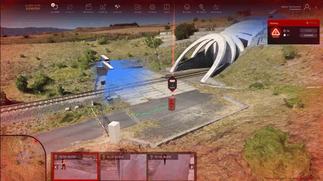
Monitoring and securing hazardous areas
Utilizing modern solutions based on laser sensors for monitoring critical locations, such as temporary pedestrian crossings or railway crossings during construction or modernization, can bring many benefits for safety management and traffic control.
Here are several possibilities offered by such a solution:
- Detection and monitoring of movement: Laser sensors can effectively detect the movement of pedestrians and vehicles in the vicinity of temporary pedestrian crossings and railway crossings. This enables continuous monitoring of traffic intensity and identification of potential hazards.
- Warning of approaching vehicles: Systems based on laser sensors can be configured to automatically generate warnings for pedestrians and drivers about approaching vehicles or trains. This increases road users' awareness and prevents potential accidents.
- Monitoring the safety of workers: Ensuring the safety of workers is essential during construction or modernization work on railway crossings. Laser sensors can be used to monitor the work area and detect hazardous situations, enabling quick response and evacuation if necessary.
- Data analysis and action planning: Data collected by laser sensors can be used to analyze traffic patterns and evaluate the effectiveness of control measures. This allows for continuous improvement of safety strategies and planning of preventive actions based on real data.
- Integration with traffic management systems: Information collected by laser sensors can be easily integrated with existing road and railway traffic management systems, enabling coordination of actions and quick response to changing conditions.
Utilizing modern solutions based on laser sensors for monitoring temporary pedestrian crossings and railway crossings during construction or modernization enables effective provision of safety for road users and workers, minimizing the risk of accidents and hazards.
By providing comprehensive solutions that support clients at various stages of railway infrastructure management, we aim to effectively contribute to achieving their business and operational goals.