
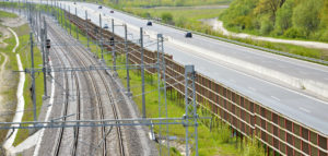
Inventory is done by photogrammetry (partly by air via helicopter and partly by rail) and laser scanning. The collected information results in height models as well as 3D models of the track and surroundings being made.
Our maintenance inspection includes for example distance measurements of assets along the track such as signs and vegetation. Every asset receives a Id number connected to SQL database as well as a map.
The inspection results in an inspection protocol where assets which are classed as dangerous for transport or which can cause disruptions to traffic are stated.
´Through our measurements specific information regarding assets such as banks, dikes, lines, wells, posts and fences is gained. When measuring tunnel contures information on the mouths and ports, normal sections and deviant sections and reinforcements is produced.

Due to everything being rendered in 3D the client can decide which measures are to be delivered, for example perpendicular from the centre of the tracks or measurements of height, width or other required co-ordinates.
Our documentation (Photography) of tunnels and mountain passes gives detailed information regarding the track and/or surroundings current status. For example reinforcements, frost isolations, views of the mountain passes and crests can be analysed.
Risk analysis besides charting is conducted. Risk analysis includes the localisation of e.g. cracks, mud zones, water, vegetation on crests and in tunnels. . We can locate all dangerous trees along the track which could cause disruption to contact lines.
Data
The presentation is implemented in a dedicated 3D program DPM Inspection legibly and quickly. Data from multiple sources are integrated in a single environment, and thanks so obtained synergies, information infrastructure is more complex and accessible.
Acquired data can also be used for:
- Measurement of geodetic coordinates and description of the elements of railway infrastructure
- implementation of the belt rail and visualization environment (threat of vegetation)
- Creation of digital maps and noise
- 3D modeling of terrain and objects related
You are welcome to use our services. We will prepare an offer specifically for your business
Contact
If you would like to know more, please contact us!