
Environmental solutions
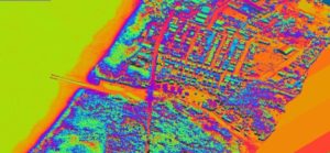
Quick and safe inventory generates images which can then be examined by experts. You can reduce the number of field trips and reduce the costs of inventory, running and planning. A correct image basis gives you an even better basis for decision making.
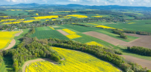
Are you interested in the volume of your forest? Are you planning a new forest?
Your organisation can use position determined images and laser data connected to GIS to make better decisions. It will become easier to plan work when you have an overview, and from the images be able to prioritise measures.
The possibility to connect information to assets in the image. at the same time as exact positioning is conducted we can inventory your forest and link specific inventory information to every separate asset.
More details are detected. The images can be reviewed more thoroughly. Forestry experts are given more time for the inspection of forests in order to localise tree diseases.
Collected data can be access via the internet from the organisations field computers and give the whole company access to the same information.
More effective control of deforestation or planting. Check that the contract is progressing as expected. Discussions can be held with the images in front of you.
Correct data can be exported to your own GIS information system in so that your information is always up to date.
More complete inventory. The stretches we have flown are automatically recreated in our software, thanks to our navigation system we can see which stretches need additional flyovers. No areas can be missed.
In laser scanned 3D models, distance, height, surface area and volume of forest or clearings be calculated. Laser scanning is conducted at the same time as other data collection.
You can produce an image history and evaluate processes over a long period.
A picture says more than a thousand words!
We help with communicating with land owners over discussions regarding compensation for felled forests.
When we document rivers or coastlines we can plan preventive measures for possible flooding. Vegetation, terrain and topography are charted at the same time.
Clearer communication. Are you discussing the same thing? Difficulty in understanding 2nd hand information? From the images collected you can discuss, control, calculate and plan.
Environmental plans and environmental consequence analysis can be conducted more thoroughly.
We can help you to document those locations where growing infrastructure or towns have a negative effect on the environment. By supplying you with the correct information we make it easier for you when making decisions.
Our offer
In terms of hydrological studies Visimind offers:
- inventory of reservoirs and watercourses, together with the adjacent area
- development of coastal elevation
- monitoring of the coastal belt (tidal range, the processes of coastal erosion, dune movement)
- assessment of the condition of coastal protection forests, and flood embankments
- imaging of areas threatened by flooding.
You are welcome to use our services. We will tailor an offer specifically for your business.
Contact
If you would like to know more, please contact us!