
Environmental solutions
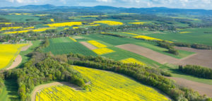
Extracted Visimind footage, orthophotomaps and LIDAR-data provide a comprehensive and accurate information about the topography of the natural environment. This information is used for conducting water, forest management and R & D purposes.
Our offer
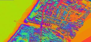
Aerial laser scanning is an efficient method for routine measurements of areas characterized by high dynamics of change. Numerical models provide input data for a variety of applications-e.g. passage of flood wave, their accuracy and timeliness of risk assessment in normal condition. Visimind offers an effective method of obtaining topographic data required to conduct proper water management, including preventive measures, such as the development of flood management.
Footage and data obtained in laser scanning technology allows for the determination of land planted with trees, foliage and the degree of fault trees and allow the characterization of vegetation and soil. Numerical models, used in space applications, managing natural resources, are a valuable asset in developing forest inventories. Thermographic materials provide an inventory of forest wildlife.
Data obtained by Visimind are applicable in eco-physio-graphic case studies, acting to-date information about the resources and the state of the environment. In addition, the base material is used in the system design of nature conservation, supplies characteristics for of coverage of environmental hazards and the development opportunities and constraints for different types and forms of use of land.
In terms of hydrological studies Visimind offers:
- inventory of reservoirs and watercourses, together with the adjacent area
- development of coastal elevation
- monitoring of the coastal belt (tidal range, the processes of coastal erosion, dune movement)
- assessment of the condition of coastal protection forests, and flood embankments
- imaging of areas threatened by flooding.
You are welcome to use our services. We will tailor an offer specifically for your business.